


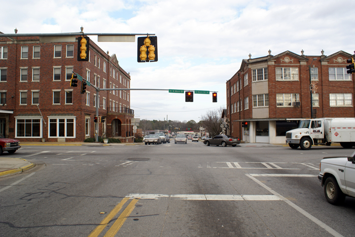
Swainsboro has been known for years as the “Crossroads of the Great South.” This crossroads is more than just the intersection of North/South Main Street and East/West Main Street, it is the crossroads of two of the most historically relevant cross-country routes in America. U.S. Route 80 intersects with U.S. Route 1 in the heart of Downtown, making Swainsboro the only place in America where these two U.S. Highways meet.
U.S. Route 80 is an east-west United States highway. As the “0″ in the route number indicates, it was originally a cross-country route, from the Atlantic to the Pacific. However, the entire segment west of Dallas, Texas, has been decommissioned in favor of various Interstate highways and state highways. Currently, the highway’s eastern terminus is in Tybee Island, Georgia, at the Atlantic Ocean. Its western terminus is at the border of Dallas and Mesquite, Texas, at an intersection with Interstate 30. US 80 originally had its western terminus in San Diego, California.

The direct predecessor to US 1 was the Atlantic Highway, an auto trail established in 1911 as the Quebec-Miami International Highway. In 1915 it was renamed the Atlantic Highway, and the northern terminus was changed to Calais, Maine. Due to the overlapping of auto trail designations, portions of the route had other names that remain in common use, such as the Boston Post Road between Boston and New York, the Lincoln Highway between New York and Philadelphia, Baltimore Pike between Philadelphia and Baltimore, and the Dixie Highway in and south of eastern Georgia. North of Augusta, Georgia, the highway generally followed the Fall Line, rather than a more easterly route through the swamps of the Atlantic Coastal Plain.
When the New England road marking system was established in 1922, the Atlantic Highway within New England was signed as Route 1, with a Route 24 continuing north to Madawaska; New York extended the number to New York City in 1924 with its own Route 1. Other states adopted their own systems of numbering, and by 1926 all states but Maryland had signed the Atlantic Highway as various routes, usually changing numbers at the state line. In 1925, the Joint Board on Interstate Highways created a preliminary list of interstate routes to be marked by the states, including Route 1 along the Atlantic. This highway began at Fort Kent, Maine and followed the existing Route 24 to Houlton and Route 15 to Bangor, beyond which it generally followed the Atlantic Highway to Miami. In all states but Georgia that had numbered their state highways, Route 1 followed only one or two numbers across the state. The only significant deviation from the Atlantic Highway was between Augusta, Georgia and Jacksonville, Florida, where Route 1 was assigned to a more inland route, rather than following the Atlantic Highway via Savannah.
One of the many changes made to the system before the final numbering was adopted in 1926 involved US 1 in Maine. The 1925 plan had assigned Route 1 to the shorter inland route (Route 15) between Houlton and Bangor, while Route 2 followed the longer coastal route via Calais. In the system as adopted in 1926, US 2 instead took the inland route, while US 1 followed the coast, absorbing all of the former Routes 24 and 1 in New England. Many local and regional relocations, often onto parallel superhighways, were made in the early days of US 1; this included the four-lane divided Route 25 in New Jersey, completed in 1932 with the opening of the Pulaski Skyway, and a bypass of Bangor involving the Waldo-Hancock Bridge, opened in 1931. The Overseas Highway from Miami to Key West was completed in 1938, and soon became a southern extension of US 1.
With the construction of the Interstate Highway System in and after the 1950s, much of US 1 from Houlton to Miami was bypassed by Interstate 95. Between Houlton and Brunswick, Maine, I-95 took a shorter inland route, much of it paralleling US 2 on the alignment proposed for US 1 in 1925. Between Philadelphia and Baltimore, I-95 leaves US 1 to pass through Wilmington. Most notably, I-95 and US 1 follow different corridors between Petersburg, Virginia and Jacksonville, Florida; while US 1 followed the Fall Line west of the coastal plain, I-95 takes a more direct route through the plain and its swamps. Although some of this part of US 1 was followed by other Interstates – I-85 between Petersburg and Henderson, North Carolina, and I-20 between Camden, South Carolina and Augusta, Georgia – the rest remains an independent route that has been four-laned in many places. By the late 1970s, most of I-95 had been completed, replacing US 1 as the main corridor of the east coast and relegating most of it to local road status.
As the main intersection of the historical North/South and East/West corridors, Swainsboro has also been the intersection of millions of travelers since 1926. Hundreds of people daily still travel U.S Route 80 and U.S Route 1 through the heart of Downtown Swainsboro, not knowing that by doing so they become part of a larger story that is shared by those who have come before them and will come after them. Swainsboro will always be the “Crossroads of the Great South” and always welcome travelers for a rest on their way to see America.
As a member of the inaugural class of US highways commissioned in 1926, US 80 was the first all-weather coast-to-coast route available to auto travelers. For a time known as the “Broadway of America”, its legendary history is second only to U.S. Route 66 in American highway folklore, as several significant historical events have occurred on or near Highway 80. Bonnie and Clyde were ambushed approximately four miles south of US 80 in Gibsland, Louisiana. Lee Harvey Oswald was captured at the Texas Theatre on Jefferson Street in Oak Cliff, which at the time was a business spur of Highway 80.